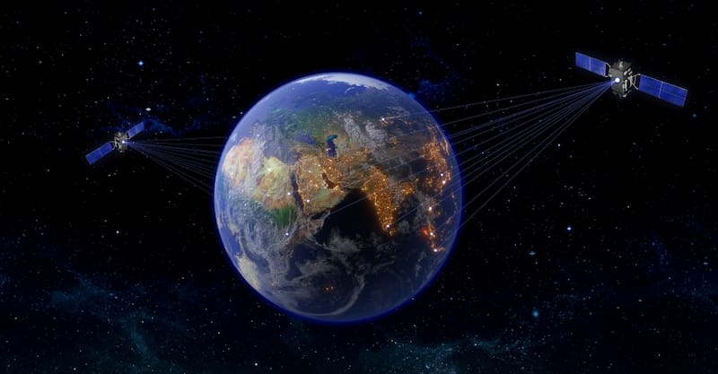
About the invisible, yet somewhat tangible, and on who tracks who.
GPS explained, how we can track our location and are we tracked.
Articles in this series, by “logical” order:
- [01] GPS, GSM, WiFi, Bluetooth, FM, Internet
- [02] Mobile phone GPS navigation – basics
- [03] OruxMaps installation and initial setup
1. Introduction
This article is an attempt to, in one place, answer several basic questions about how smart devices (mobile phones) know their location and what is required for that. It mentions some facts you probably already know, in order to lay a foundation since this is intended as a first in a series of posts about using smartphones for navigation in the wilderness.
The goal is to explain various technologies that a smart device (smartphone) uses, and which of those is used for what in order to determine a location and use that information in navigation apps. Since applications need maps and get them over the Internet, the technologies will also be viewed from the price/cost point of view.
2. Questions
When someone wants to use navigation on their smart device, there usually are a few questions. The most obvious and the most practical ones are related to which application to use and how to use it – and those questions will be answered in the second post of this series.
However, there are some other questions, best answered right at the start, because they allow for a better understanding of this topic.
- What kind of phone do I need?
- What is GPS and how does it work, and are there other ways to determine one’s location?
- Do I need Internet for navigation, and what kind of Internet connection (Wi-Fi, or my mobile service provider’s), and how much does that cost?
- Am I being tracked when I turn on a GPS on my smartphone?
3. About the tangible
Imagine you are sitting on a bench in the city centre with your smartphone at hand. If you are in the centre of my city (Novi Sad), in front of you there is a statue of Svetozar Miletić. What could you wish to do with your phone…
- Close the application where you saw the city map and your location, and which lead you to the bench.
- To enjoy the nice spring day and sunshine on the bench, listening to the music of a local radio station over your Bluetooth speakers.
- Call someone over the PHONE and have a talk, or send an SMS.
- Talk, or send a message, or an image, using Viber, WhatsApp, or some other similar application.
- Open a web browser and read up on Svetozar Miletić, or see a YouTube video about him.
- Get prepared for a mountain hike (the nearest one being Fruška Gora), by downloading some maps.
All of this is tangible in a way, but it is provided using the invisible waves – that differ drastically from one service to another (and have a common name of “electromagnetic waves” – but that is not relevant for this post).
It is all provided by your smartphone. From now on, we will call your smartphone a “smart device”, in order to emphasize the fact it contains several different microchips. One is the main chip, used to control all the others, and here we’ll call it a Processing chip and will no longer mention it until near the end. Of all the rest, each is in charge of a particular service that a smartphone can provide, and understands a single type of the above mentioned invisible waves.
For example:
One is a GSM chip. It enables the service we’ll call GSM Phone. That chip receives and sends GSM waves (the word “sends” is underlined, because some services, like FM, and GPS only receive waves). Thanks to this service, you can make phone calls, send SMS, and use the mobile Internet.
But before we get back to this, let’s list all the services, starting with the probably least used one, but the easiest one to understand.
Each of these services will be discussed from the point of the service it provides, price, and its role in determining our location. When it comes to location, we’ll try to answer these two questions:
- Does our device know where it is, based on the information provided by the service?
- Does the service provider know our device’s location?
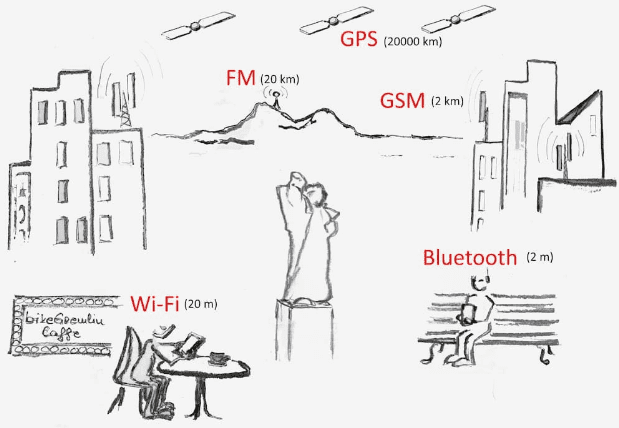
Picture 1
Later, we will rephrase the second question into the question of whether a third party (like Google) knows the location of our smart device when using a service being discussed.
4. FM Radio
Perhaps it’s a bit strange to even mention this, but listening to a local radio station will help us remember what we all know about the invisible waves that are all around us.
So, even if you’ve never tried it, your smart device has a chip that enables it to provide the service of listening to the local FM radio stations (it will only ask that you plug in your headphones that will be used as a receiving antenna).
– not for the iPhone users, primarily for manufacturer’s marketing decision (that I can’t understand) – remark by Relja
4.1. Service and how does FM radio work?
Local radio station transmits its program over an antenna. All the devices (your smart device, or an ordinary radio at home) that have an appropriate chip for demodulating these waves can pick a frequency and listen to one of the many available stations that broadcast their program in your area, each using a different frequency.
Distance: several tens, or hundreds of kilometres.
4.2. Price
This service is free. You are not paying anyone for listening to the radio.
4.3. Location
Does our device know where it is, based on the information provided by the service?
Radio station emits its waves and your device just receives them. Based on that, your device has no information on its location.
Does the service provider know our device’s location?
Your device doesn’t send anything back to the radio station. So the station has no idea who is listening and where they are.
4.4. Digression – Internet radio stations
We all know what the Internet is. It’s a network that allows the smart devices to connect (the term smart devices is used here to encompass both the smartphones, and tablets, personal computers, servers and other networking devices). Some of those devices offer some functionalities, and if we have a certain application on our smart device, we can use them.
On your smart mobile phone, you have various applications that use the Internet.
So, for listening to FM radios you could use one of the many applications that don’t use the FM chip directly. They use the Internet for playing all the FM radio stations – over 50 thousand in the world. Plus those who exist only on the Internet, without broadcasting over FM waves. This is thanks to the fact that some stations broadcast their signal in a form that can be transmitted over the Internet. In that case, a song may be a few seconds delayed compared to listening to it directly over the FM chip, and that could cost you some money for the Internet data transfer, depending on how your smart device is connected to the Internet at that time (over Mobile Data – which is the name for data transfer using GSM service of your mobile phone service provider, or using a Wi-Fi network).
Besides that, you might have to pay for an application.
5. GSM (Global System for Mobile communication)
Telephone. Historically looking it was originally a device that is at home, connected via a wire from a wall.
GSM technology has enabled the phone to be carried everywhere. It has enabled us to make phone calls, and use some other services.
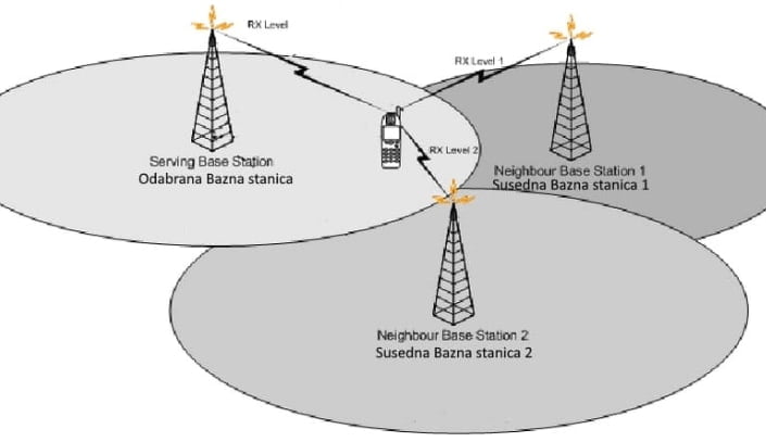
Picture 2
5.1. Service and how does GSM work?
GSM service is provided by your mobile phone provider (Orange, Vodafone, AT&T, Comcast…).
You get a SIM card from them and are charged depending on the package you chose.
For this article, we will consider that GSM offers three services (sub-services):
- Making phone calls.
- Sending SMS (and MMS) messages.
- Mobile Internet (Mobile Data).
Mobile phone provider has base stations covering land regions. They emit GSM waves (similarly to how we described it in the chapter about FM radio transmitter antennas), which are received by a GSM chip in your smart device. But your smart device also sends GSM waves to the nearest base station it chose for communicating with at a given time. That way, you can make phone calls, exchange SMS, or use the Internet connection.
Distance: several kilometres (or tens of kilometres).
5.2. Price
Your mobile service provider has their packages and prices for each of the above-noted services (these can drastically increase if you go to another country and get charged for the roaming service). Phone calls are measured in minutes, SMS by the number sent, used Internet is charged by how much data you received, or sent.
5.3. Location
Your smart device, i.e. GSM chip in it, tracks the signal strength of all the base stations within reach and decides to use the one with the best signal quality. So the device knows which base stations are within range, but the base stations also know that the device is in their range and how strong the signal coming from it is.
Does our device know where it is, based on the information provided by the service?
A smart device knows only which base station it is connected to, which is not very useful for knowing where we are. In other words, the two applications used for determining our location, which we will note later, will ask for enabling a GPS receiver (there is another aspect for this consideration that will be mentioned later in the chapter: 10. Configuring location service in smart device options).
Does the service provider know our device’s location?
Mobile service providers can determine our device’s location with a precision of about 50 metres if we are in an urban area, with many base stations densely placed. This precision decreases as we move away from the cities, to more rural areas, with fewer base stations.
5.4. Digression – Phone calls and messaging over the Internet
You can use applications that “simulate” phone calls, or message sending. Like Viber, WhatsApp… Then you are not using minutes, nor the SMS messages from your package, but it could cost you some money for the Internet data transfer, depending on how your smart device is connected to the Internet at that time (using Mobile Data, which is data transfer over the GSM service of your mobile phone provider, or using a Wi-Fi network).
6. Wi-Fi (wireless)
We saw that Mobile Data service from a mobile phone service operator is one way for your smart device to connect to the Internet. Wi-Fi is the other way for it to connect to the Internet.
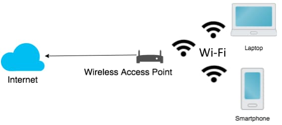
Picture 3
6.1. Service and how does Wi-Fi network work?
Wi-Fi is a way for the devices that have a Wi-Fi chip to connect to a wireless network.
One of the devices acts as the main device (Access Point) and the others are connected to it. If that device is connected to the Internet (in any way), the other devices can connect to the Internet over that main device.
Distance: several tens of metres.
6.2. Price
Wi-Fi network is free in general. It usually just takes a password to connect to one.
Note that the Wi-Fi network doesn’t offer an Internet connection in and of itself, it just offers a connection to another device, which can be (and often is) connected to the Internet. That device, acting as an Access Point does pay for the data transfer in one way, or another, but it usually allows you to use that service for free (like free Wi-Fi in an Internet cafe).
But if we assume that our Wi-Fi connection is free, then we could listen to an online FM radio, or use Viber for making phone calls, or sending messages – for free. We could also download maps for navigation applications that help us navigate in cities, or in the countryside. Just bear in mind – Wi-Fi range is just several tens of meters.
6.3. Location
Does our device know where it is, based on the information provided by the service?
Smart device offers only the information which Wi-Fi network it is currently connected to, which isn’t too useful in determining where exactly we are. In other words, the two applications used for determining our location, which we will discuss later, will ask for enabling GPS receiver (there is another aspect of this which will be mentioned in chapter: 10. Configuring location service in smart device options).
Does the service provider know our device’s location?
Wi-Fi service is provided by the Access Point owner. They definitely know that you are somewhere in a several tens of metres proximity, since you are connected to their Access Point, while if they wish to, they could quite accurately determine your location. Probably to within a few metres (interesting fact is that, if they wish, they could also track all the data going from you to the Internet – but that is not the topic of this article – for more details see the first 3 chapters in the post about WordPress website protection – safe habits).
7. Bluetooth
Even though it plays no part in determining a location, mentioning this only to complete the chips in your smart device that deal with some kind of invisible waves.
7.1. Service and how does Bluetooth work?
Devices that have a Bluetooth chip can be connected for sharing data among themselves, or Bluetooth can be used to connect wireless headphones, or a speaker with a smart device.
Distance: a few metres.
7.2. Price
Completely free.
7.3. Location
Says nothing to anyone about the location.
8. GPS (Global Positioning System)
And finally we come to the service that is the most interesting for our desire to know the location of our smart device.
Picture 4
Picture 5
8.1. Service and how does GPS work?
8.1.1. History and parts
GPS was developed in the 1970s by USA defence department, originally for military use, but later it was enabled for free civilian use. It consists of 3 parts:
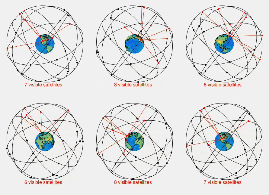
- About 30 satellites.
- Countless GPS receivers, i.e. GPS chips, with one being in your smart device.
- Several land based control units that manage the satellites.
1. Satellites
Distributed so that while they circle the Earth, there are enough visible satellites from each point for any receiver to be able to calculate its position.
Circling at height of around 20,000 km.
They are constantly broadcasting signal, but they don’t care and they have no information on who receives that signal. Similar to the FM radio.
2. GPS receivers
Each device has a GPS chip that can calculate its own location. What it does with that information depends on the device. GPS system, i.e. chip, only gives the current location – nothing more.
So if we wish to see an arrow on a map pointing to our location, the device must provide a screen, a map, and an application. If we wish to share that information with someone, in addition to an application, we’d also need some communication channel to send it over, because GPS system is a one-way system – signal only goes from the satellite to the receiver.
Very much like the above mentioned FM radio.
3. Land based control stations
They synchronize the time on the satellites and do other things that are of no interest to us now.
Only, they should not be mixed with the occasional mentioning that the GPS system precision can be improved in some important areas by broadcasting GPS signal from land based antennas. That is done near the airports for example, but this also doesn’t interest us now.
8.1.2. Very little mathematics
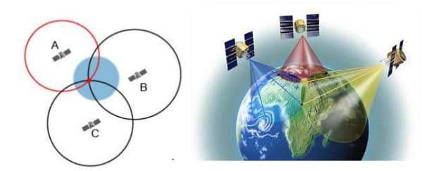
For a GPS receiver to know its location, it needs the information from at least four satellites. Why four? Well, this technical information is not really necessary for us, but if you don’t run away from a little mathematics, the basic idea how this works is not too complicated for us to try and explain it – if a bit simplified.
For start, imagine that GPS receiver and all the satellites have ideally synchronized clocks. In the signal broadcasted by a satellite, there are two pieces of information: satellites position, and the time when the signal was broadcasted.
When a receiver gets the signal, it looks at its clock to see how long it took since the signal was broadcasted. We all know, and so does the receiver too, that the speed of the (electromagnetic) waves that brought the signal is a constant and exactly how much it is (300,000 km/s). We all know, and so does the receiver too, that the speed equals traveled road length divided by the time of the travel.
So the receiver knows the speed and the time, so it can easily calculate the distance from the satellite.
All the points at a given distance from the satellite make a sphere. Intersection of three spheres around three satellites will give us one point on Earth’s surface, where we are located.
What do we need the fourth satellite for then? Well, all the satellites do have ideally synchronized clocks and there are special systems that take care of that. But no one makes sure that each particular GPS receiver has their time synchronized with the satellites, for two reasons: firstly because it is not possible, and secondly because a bit of mathematics makes that be unnecessary. Receiver’s clock is late, or ahead of satellite’s time by the same amount for every satellite, so the fourth satellite is the fourth variable of a four variable sstem (and as a result of that our receiver has very accurate time at its disposal, so GPS technology is sometimes used for that purpose alone).
8.1.3. Precision
GPS system precision is hampered by the (bad) weather, terrain configuration, building walls etc. That is why it is better for the receiver to be within range of as many satellites as possible, so that location determination is as precise as possible.
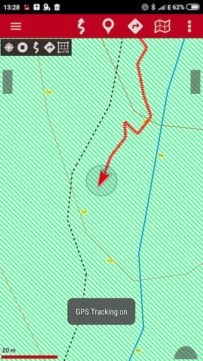
Precision is roughly 5 metres. GPS applications often mark the location using an arrow, and mark the measurement precision using a circle around it.
Picture 6
8.2. Price
This service is free. You are not paying anything to anyone in order to know the coordinates of your location (though you might pay for an application that does something with the information, and depending on how you download the maps that you are likely to require, you might pay the mobile phone provider for the Mobile Data using – if you are downloading maps over the Internet – but in case you came well prepared, you won’t be paying anything – but more on that once we get back to that bench and go over it all together).
8.3. Location
We have already answered this, but let’s repeat the two questions one more time.
Does our device know where it is, based on the information provided by the service?
Yes.
Does the service provider know our device’s location?
No.
It is clear that GPS is used for determining our location. Let us explain what exactly “our location” is.
9. Location
Picture 7
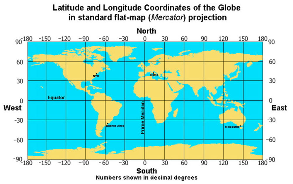
Our location is expressed using two coordinates that pinpoint an exact location on a map shown in picture 7. These coordinates are the distance from two imaginary lines on Earth: Equator, and the Prime meridian. The unit used to express it is not in kilometres and metres, but in degrees. Degrees are divided in minutes, while minutes are divided in seconds.
And just a small note that one second difference does not equal the same distance in kilometres on all the parts of Earth, so: each point has its coordinates and we no longer concern ourselves with what they mean.
Even though these coordinates are used to pinpoint one spot, people haven’t really agreed on how exactly to write them down, so there are slight variations in the ways they are expressed. So the coordinates of the monument we saw at the beginning could be written as:
- N45.255053, E19.844985 – Decimal degrees (DD).
- N45°15.30318, E019°50.6991 – Degrees and decimal minutes (DMM).
- N45°15’18.191″, E19°50’41.946″ – Degrees, minutes, and seconds (DMS) – with seconds using a decimal.
Letters N and E mean that we are looking for the coordinates in the top right quadrant, i.e. northern (N) of Equator, and eastern (E) of the Prime meridian.
For quadrants that are south from Equator, the mark is S, while the ones western from the Prime meridian, the mark is W.
You can come across notations that use the minus sign (” – “) for southern and western quadrants.
In the following texts from this series, we will be using some free tools from gpsvisualizer.com website, to demostrate some ideas and posibilites, so here is their online converter:
https://www.gpsvisualizer.com/calculators
And just a brief answer to a question about where and how we can see these coordinates in that format and why we might need them. In general, there are two scenarios:
- we know a place and want its coordinates
- we have the coordinates and wish to see which place that is
Concrete places of display and entering the coordinates depend on the applications used. Here I’ll give a few example.
Example 1
How I came to the coordinates of the monument in my city’s centre.
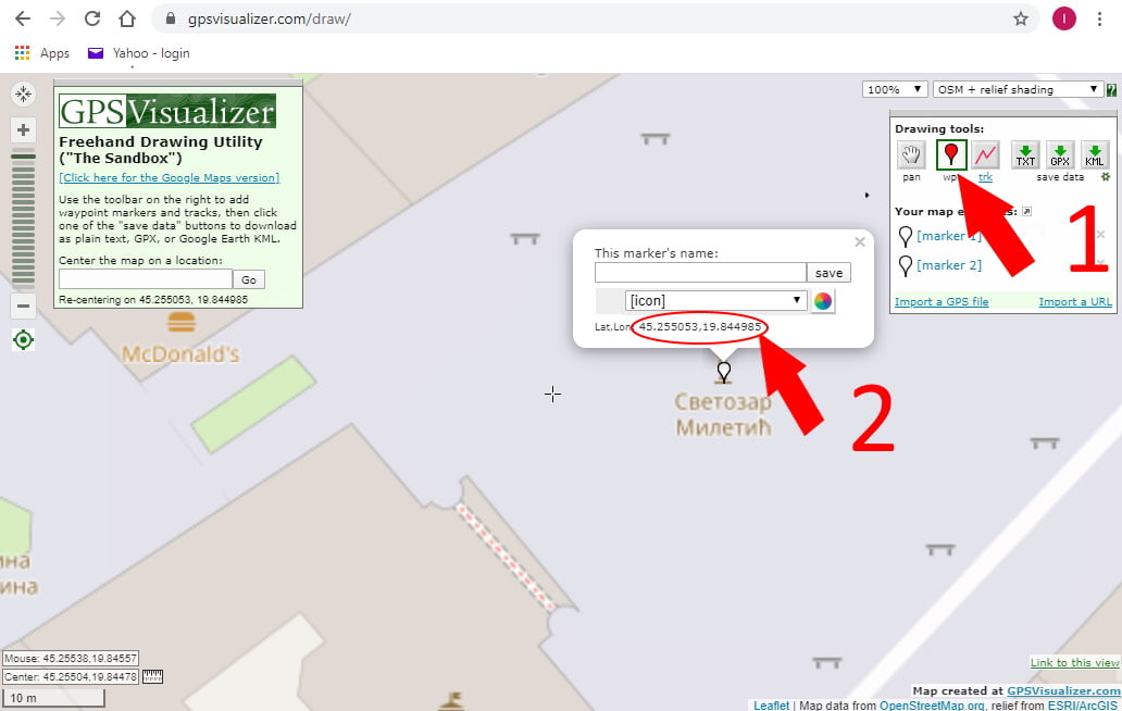
I used the tool we will later use for drawing routes and marking Waypoints:
https://www.gpsvisualizer.com/draw/
I positioned the map point of interest and chose the icon WPT [1] which adds a point to the map.
I clicked on the desired spot, and as the application was creating the point, it also showed its coordinates [2].
Picture 8
Example 2
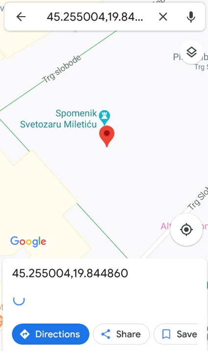
When I started Google maps application on my smart device, and clicked near the monument, it showed the coordinates of the chosen point, separately, and in the search field, then offering contents it considers relevant for that location.
Picture 9
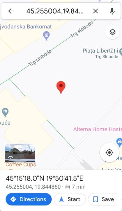
Upon entering the coordinates in the search field, the application offers to lead us there.
Picture 10
10. Configuring location service in smart device options
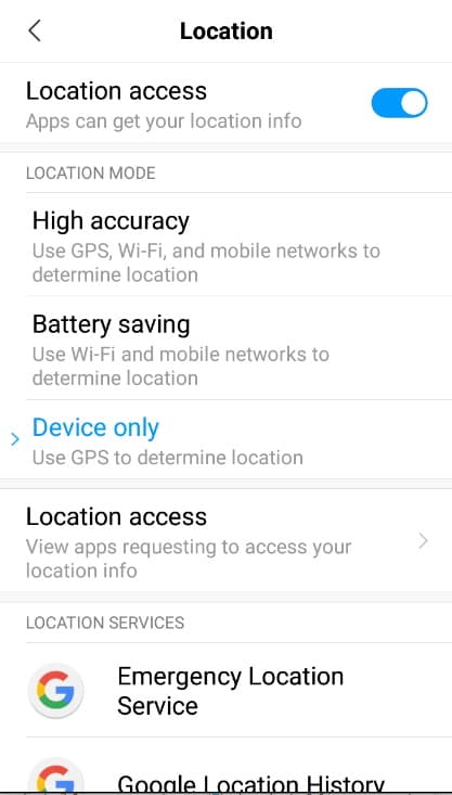
In order to make your smart device aware of its location, or to make it possible for apps to use that information, you have to allow it in the settings options of your smart device. Usually that menu is accessible through either general settings option by a long press on GPS button, or through configuration menu. For example:
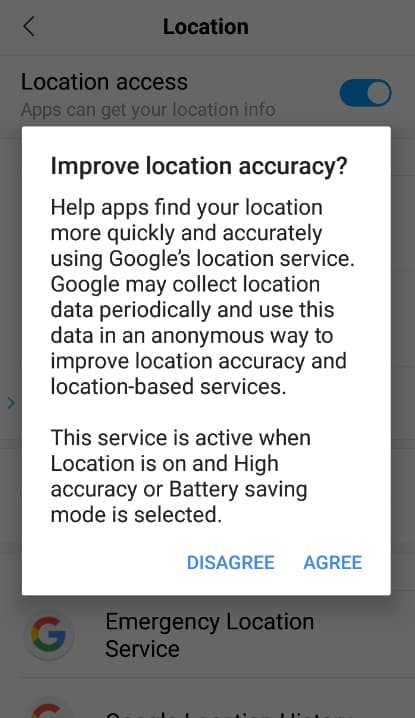
Settings -> Additional settings -> Privacy -> Location
Picture 11
Let’s pause here and give some general knowledge about what each of these options for location determination mean. Actually, there are two different options (third one is a summation of the first two options).
- To use only GPS service
- To use subsidiary options that are classified under Battery saving option, which contain possibilities to determine location using Wi-Fi network and GSM network.
We already talked about GPS service, but in chapters about Wi-Fi and GSM services we said that those can NOT help us determine a location.
When you choose to enable High accuracy option, or Battery saving, i.e. enable both Wi-Fi and GSM base stations to be used for determining your location, you are allowing something that Google calls Google location service.
Picture 12
What does it mean for Google to allow it to use information that your device has about base stations of your GSM operator and Wi-Fi networks?
Honestly, I don’t know all of that in detail, but without getting into the technical nitty-gritty details and possibilities, we will try to form an idea about how all the information and data can be collected and used later on for location determination.
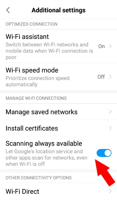
But first, we will show one more setting that is a bit hidden and it is found in a completely different place:
Settings ->Wi-Fi -> Additional settings
Picture 13
So, we have already mentioned that our phone doesn’t DIRECTLY benefit from knowing which base stations of GSM operator are available at the moment, or which Wi-Fi Access Points and type of their signal. And let’s assume with high certainty that their owners are not sending data that is at their disposal.
But let’s imagine that all the data about the currently available GSM and Access Point signal availability and strength, along with the current location which is known using the GPS service, smart device sends to a common database that records all the attributes of the signals, pairing them with the GPS provided location information. We could say that in someway it makes something like a fingerprint of that place. That smart device could also be a car driven through town but it is even more convenient if that data is being sent by a large number of smart devices.
At this point, if that type of database is queried by a device that doesn’t have GPS service, but it does have the information about current state of GSM and Wi-Fi signal, that base could, based on all other data for that signals combination, or “fingerprint”, give the location that it thinks the device has.
Put simply – that could be the Google location service, or just a small part of it.
Other than some other technical ways how all the GSM and Wi-Fi base station data could be used by this service to determine the location, the service could also be helped by the device itself using the microchips it contains.
For example, let’s imagine that in some way the smart device knows its last location but afterwords it doesn’t have any additional data provided by waves or the aforementioned services. If it contains a chip that measures the speed of movement, and a chip that serves as a compass, using this data it could potentially calculate its new current location at any given moment.
But is this new data being sent back to that base – that I do not know. Up until this point we have been dealing with our desire to know where we are and any help to determine that was welcomed, for our own sake. And we will explore some broader opinions on the topic in the next chapter.
To finish this, just a few words about specific usability of Battery saving option without having GPS service on, using the example of two applications that use location in my city.
Orux application explicitly asks for GPS service to be turned on.
Google Maps also doesn’t provide any useful information without having GPS on (maybe signal interleaving density wasn’t enough in my city to have enough data to determine location precisely enough).
Device only option will suffice to be checked for all that will be discussed in the following articles.
11. Other than ourselves, does anybody else know our location, is anyone tracking us, privacy?
This is not the base theme for this article, but considering that questions related to this topic are tightly connected to this article, here are some opinions on those.
Usually, the question is: “if I turn on GPS, are the satellites following me?”
The answer is pretty obvious by now, isn’t it? No, satellites and those who manage them do not know anything about our location, but that doesn’t stop any third party and those that track everything about us to also track our location.
GSM operators can track location, but it would also be logical to say that this is not very important to them. What is important to them is the information how to arrange their base stations, and with what capacity, while the location of any specific device and all data related to it is only useful to them if they are being queried by some state authority.
On the other hand, we know that Google, Microsoft, Apple and others are based on collecting all the possible information on their users.
In short – if you want privacy, do not use smart devices (or at least devote your attention to carefully choosing which options, that are checked by default, to un-check).
For example, at the bottom of the photo that shows Location option settings are some other apps that use Goggle Location Service. Google location history is one of them and it asks you if you would like Google to help you by remembering all of your locations (the question could be if you would like for it to show you all that it records).
When talking about GPS service alone, you could use specialized devices (for example Garmin) which do not have internet connection, hence no connection to Google and other “data collecting” services, and the chances are that you will have better precision with such devices as well as robustness in harsh use conditions.
But let’s go back again to the topic and let’s summarize the answers of the initial questions.
12. Answers – in short
1. What kind of a phone and apps do I need, namely which app has brought me to the bench and did that cost me?
Processor chip determines power and strength of a smart device, but every phone that calls itself smart is also smart enough to run these apps.
There are, of course, many apps, but let’s say that we were brought to the bench by Google Maps app.
Let’s say that you haven’t prepared before visiting my city, namely that you hadn’t downloaded any maps beforehand. This means that while you were walking around town, Google Maps was downloading parts of the city that were needed, but only those that were actually needed. Since you haven’t been connected to any Wi-Fi those downloads were billed by your mobile operator by how much it took to download that data.
Where you were currently at the moment was shown using GPS service for which you do not need to pay to anyone.
2. Can it be free?
Yes, it can. But, you need to find a free Wi-Fi network. Let’s say that that bench is close enough to your local coffee shop for who’s Wi-Fi you have a password.
In that case, talking via Viber does not cost you anything, as well as watching YouTube, or surfing the internet, but you could also use it to download beforehand any maps that you know are going to be needed for tomorrow’s trip to Fruška Gora. And if you prepare them in advance, not only will that be free, but you will also have them at your disposal even in some parts of Fruska Gora where there is no mobile operator signal, hence access to the Internet.
For trips, or hikes in the nature, we recommend the aforementioned free app Oruxmaps. How to prepare yourself for a hike and in what ways you can prepare your maps and everything else that you might need, we will discover in future articles.
13. BikeGremlin’s comment
The main purpose of this article is to help explain the topic of using smartphones for navigation in the wilderness (hiking, cycling, etc.). However, because of frequently asked privacy and tracking related questions, Gox and I decided to touch on that topic as well. For understanding the “tracking & privacy” stuff, it helps a lot if one understands how various types of waves and services work, i.e. what they (theoretically) can, and can not do.
This article, written by my good friend Gox (with my minor editing and consulting) who wished to remain practically anonymous, is the most comprehensive one on this topic I could find, i.e. containing a decently rounded set of info, all in one place (if I do say so myself). As you could tell, no credentials, like “XX years of experience with YY tech” were noted for the (co)author – because I believe content should be weighed by itself, and fancy titles are often (ab)used to mask poor quality content as more relevant than it really is.
Use your own critical thinking, and consult experts – don’t take anything you see online for granted.
One of the reasons for writing this comment is the fact that it got censored on Reddit’s VPN subreddit. For full disclosure, a member posted this question:
One thing I’m unclear about and I’m not sure if it’s just marketing, but can apps access my location if I have a VPN on? Specifically with whatsapp, I use it with an always on VPN, and have never given the app access to my location. I noticed though that mapping apps still can still estimate my location quite well even while using a VPN. I’m finding mixed info online so I’m just wondering if anyone on this sub has knowledge on this. Thanks
squeezienums
To which I replied:
My friend and I wrote an article on mobile phone navigation, in general, that also touches on the topic of tracking – maybe it could help you find the answers:
bikegremlin
Link to this very article
Only to get notified of my comment having been removed, with this explanation:
Thank you for taking the time to post in /r/VPN but your comment has been removed for:
paperplans5
No irrelevant personal sites.
No pushing of traffic to irrelevant personal sites. If you have any questions or believe that there has been an error, you may PM the moderators.
I don’t like participating in communities with such moderation policies – i.e. removing what I consider to be relevant answers to a question, only because they are shared using a link to a website, because hyperlinks are one of the things that make the Internet good and useful.
The alternative to linking is typing (long) answers. Why do I avoid doing that on forums and social networks for the things I already have posted on my website? There are two main reasons:
- Saving myself the time and the effort.
- Keeping all the updates and edits in one place (the website), so it’s easily kept up-to-date as new info comes along, and as peer expert feedback helps correct and improve the info.
Last updated:
Originally published:

